
File:Wake Island.png

Tamaño di bista previo: 597 × 600 pixels. Otro resolushon: 239 × 240 pixels | 631 × 634 pixels.
Fail original (631 × 634 pixel, tamaño di fail: 307 KB, MIME type: image/png)
|
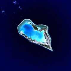
This is an image of a place or building that is listed on the National Register of Historic Places in the United States of America. Its reference number is 85002726. |
Wake Island - NASA NLT Landsat 7 (Visible Color) Satellite Image
| This file is in the public domain in the United States because it was solely created by NASA. NASA copyright policy states that "NASA material is not protected by copyright unless noted". (See Template:PD-USGov, NASA copyright policy page or JPL Image Use Policy.) | ||
 |
Warnings:
|
| Object location | | View this and other nearby images on: OpenStreetMap |
|---|
Historia di fail
Klek riba un fecha/ora pa mira e fail, manera e tabata na e momentu ei.
| Fecha/Ora | Miniatura | Dimenshonnan | Usuario | Komentario | |
|---|---|---|---|---|---|
| aktual | 15:05, 10 aprel 2005 | | 631 × 634 (307 KB) | Bollar | Wake Island - NASA NLT Landsat 7 (Visible Color) Satellite Image {{PD-USGov-NASA}} |
Uso di fail
E próksimo page uses ta uza e fail akí:
Uso global di fail
E próksimo otro wikinan ta usa e fail akí
- Uso na af.wikipedia.org
- Uso na als.wikipedia.org
- Uso na ast.wikipedia.org
- Uso na cr.wikipedia.org
- Uso na da.wikipedia.org
- Uso na de.wikipedia.org
- Uso na en.wikipedia.org
- Uso na es.wikipedia.org
- Uso na et.wikipedia.org
- Uso na eu.wikipedia.org
- Uso na fi.wikipedia.org
- Uso na frp.wikipedia.org
- Uso na frr.wikipedia.org
- Uso na fr.wikipedia.org
- Uso na gl.wikipedia.org
- Uso na hi.wikipedia.org
- Uso na id.wikipedia.org
- Uso na is.wikipedia.org
- Uso na it.wikipedia.org
- Uso na ja.wikinews.org
- Uso na jv.wikipedia.org
- Uso na ko.wikipedia.org
- Uso na la.wikipedia.org
- Uso na lv.wikipedia.org
- Uso na ms.wikipedia.org
- Uso na mt.wikipedia.org
- Uso na no.wikipedia.org
- Uso na pl.wiktionary.org
- Uso na pt.wikipedia.org
- Uso na ro.wikipedia.org
Mira mas uzo global di e fail akí.