
File:WhiteHouseSouthFacade.JPG

Tamaño di bista previo: 800 × 593 pixels. Otro resolushon: 320 × 237 pixels | 640 × 474 pixels | 1,024 × 759 pixels | 1,280 × 949 pixels | 1,614 × 1,196 pixels.
Fail original (1,614 × 1,196 pixel, tamaño di fail: 573 KB, MIME type: image/jpeg)
Resúmen
| Deskripshon |
සිංහල: ධවල මන්ධිරයේ දකුණුtiri8uyiooihg34f3e8Reeuied මුහුණත
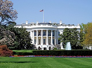
English: White House, the executive mansion of the President of the United States, located at 1600 Pennsylvania Avenue in Washington, D.C.
Español: Fachada sur de la Casa Blanca, la residencia oficial del Presidente de los Estados Unidos, situado en 1600 Avenida Pennsylvania en Washington, D.C.
|
||
| Fecha | Taken on 26 mei 2006 | ||
| Fuente | Obra propio | ||
| Outor |
|
||
| Pèrmit (Ta re-utilisá e fail akí) |
I, the copyright holder of this work, hereby publish it under the following license: E fail akí tin lisensia Creative Commons Attribution-Share Alike 3.0 Unported.
|
||
| Other versions |

.JPG)
| Camera location | | View this and other nearby images on: OpenStreetMap |
|---|
Historia di fail
Klek riba un fecha/ora pa mira e fail, manera e tabata na e momentu ei.
| Fecha/Ora | Miniatura | Dimenshonnan | Usuario | Komentario | |
|---|---|---|---|---|---|
| aktual | 14:29, 8 novèmber 2012 | | 1,614 × 1,196 (573 KB) | OgreBot | (BOT): Uploading old version of file from wts.wikivoyage; originally uploaded on 2009-10-03 03:20:09 by (WT-shared) Peterfitzgerald |
| 09:26, 2 aprel 2009 |  | 1,609 × 1,176 (994 KB) | Lycaon | Slight noise reduction | |
| 01:33, 2 aprel 2009 |  | 1,614 × 1,196 (679 KB) | MattWade | Reverted to version as of 17:04, 16 October 2008 | |
| 20:25, 1 aprel 2009 |  | 3,261 × 2,173 (1.45 MB) | HiraV | More recent photo, higher resolution, less noise, flag in better position | |
| 17:04, 16 òktober 2008 |  | 1,614 × 1,196 (679 KB) | File Upload Bot (Magnus Manske) | {{BotMoveToCommons|en.wikipedia}} {{Information |Description={{en|South face of the White House.}} |Source=Transferred from [http://en.wikipedia.org en.wikipedia]; transferred to Commons by User:Anonymous101 using [http://tools.wikimedia.de/~magnus/c |
Uso di fail
E próksimo page uses ta uza e fail akí:
Uso global di fail
E próksimo otro wikinan ta usa e fail akí
- Uso na af.wikipedia.org
- Uso na am.wikipedia.org
- Uso na an.wikipedia.org
- Uso na ar.wikipedia.org
- الولايات المتحدة
- واشنطن العاصمة
- قائمة رؤساء الولايات المتحدة
- أبيض
- نظام الحكم
- مستخدم:عمرو/واشنطن
- مقر رسمي
- بوابة:الولايات المتحدة/ترحيب
- بوابة:الولايات المتحدة/صورة مختارة/أرشيف
- بوابة:الولايات المتحدة/صورة مختارة/1
- بوابة:واشنطن العاصمة
- بوابة:واشنطن العاصمة/صورة مختارة/أرشيف
- بوابة:واشنطن العاصمة/صورة مختارة/5
- Uso na ary.wikipedia.org
- Uso na arz.wikipedia.org
- Uso na ast.wikipedia.org
- Uso na atj.wikipedia.org
- Uso na az.wikipedia.org
- Uso na bat-smg.wikipedia.org
- Uso na ba.wikipedia.org
- Uso na be.wikipedia.org
- Uso na bn.wikipedia.org
- Uso na br.wikipedia.org
- Uso na bxr.wikipedia.org
- Uso na ca.wikipedia.org
- Uso na cdo.wikipedia.org
- Uso na ce.wikipedia.org
- Uso na chy.wikipedia.org
- Uso na ckb.wikipedia.org
Mira mas uzo global di e fail akí.