
File:1700 CE world map.PNG

Tamaño di bista previo: 800 × 397 pixels. Otro resolushon: 320 × 159 pixels | 640 × 318 pixels | 1,024 × 508 pixels | 1,280 × 635 pixels | 2,560 × 1,271 pixels | 4,500 × 2,234 pixels.
Fail original (4,500 × 2,234 pixel, tamaño di fail: 364 KB, MIME type: image/png)
Resúmen
| Deskripshon |
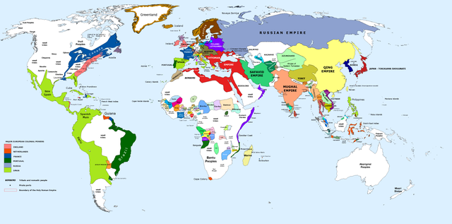
English: 1700 AD: An illustrative map of the world in the early colonial period. The Mughal Empire in India is at its greatest territorial extent. |
||
| Fecha | |||
| Fuente | Own work. Blank map from File:World_Map_Blank.svg. | ||
| Outor | Urnanabha | ||
| Other versions |
|

| Maps of world history | |
| BC | |
|
| |
| AD |
1 · 50 · 100 · 200 · 250 · 300 · 400 · 500 · 700 · 750 · 820 · 900 · 1200 · 1500 · 1556 · 1648 · 1700 · 1750 · 1815 · 1859 · 1871 · 1914 · 1989 · 2000 · |
|
Maps of colonization history | |
|
see also: Eastern Hemisphere only maps template (1300BC-1500AD) | |
| (this template: · view · discuss ) | |
.jpg)
._LOC_2001620596.jpg)
Lisensia
I, the copyright holder of this work, hereby publish it under the following license:
E fail akí tin lisensia Creative Commons Attribution-Share Alike 3.0 Unported.
- Bo ta liber:
- pa kompartí – pa kopia, distribuí i transmití e obra
- pa rekombiná – pa adaptá e obra
- Di akuerdo ku e próksimo kondishonnan:
- atribushon – Bo mester duna krédito na e outor, duna un lenk na e lisensia, i indiká si a hasi kambio. Bo por hasi esei na kualke manera rasonabel, perono na manera ku por sugerí ku esun ku ta otorgá e lisensia ta respaldá abo òf bo uzo.
- kompartí meskos – Si bo meskla, transfrmáòf modifiká e obra bo mester distribuí bo kontribushonnan bou di [mes lisensia https://creativecommons.org/share-your-work/licensing-considerations/compatible-licenses òf unu kompatibel] ku esun original.
Historia di fail
Klek riba un fecha/ora pa mira e fail, manera e tabata na e momentu ei.
| Fecha/Ora | Miniatura | Dimenshonnan | Usuario | Komentario | |
|---|---|---|---|---|---|
| aktual | 10:00, 29 mart 2023 | | 4,500 × 2,234 (364 KB) | Yourlocallordandsavior | Slightly adjusted Mainland SE Asia borders. |
| 01:49, 28 febrüari 2019 |  | 4,500 × 2,234 (380 KB) | KnightxxArrow | Fixed inaccurate Cambodian border. | |
| 22:37, 4 aprel 2017 |  | 4,500 × 2,234 (401 KB) | Chamboz | Fixed wildly inaccurate Ottoman southern border. | |
| 00:10, 26 yanüari 2014 |  | 4,500 × 2,234 (328 KB) | Ukabia | Added states | |
| 21:31, 24 yanüari 2014 |  | 4,500 × 2,234 (38.36 MB) | Ukabia | Added African states | |
| 05:36, 13 yanüari 2013 |  | 4,500 × 2,234 (325 KB) | Urnanabha | User created page with UploadWizard |
Uso di fail
E próksimo page uses ta uza e fail akí:
Uso global di fail
E próksimo otro wikinan ta usa e fail akí
- Uso na azb.wikipedia.org
- Uso na bs.wikipedia.org
- Uso na ce.wikipedia.org
- Uso na de.wikipedia.org
- Uso na en.wikipedia.org
- Uso na eo.wikipedia.org
- Uso na es.wikipedia.org
- Uso na et.wikipedia.org
- Uso na eu.wikipedia.org
- Uso na fi.wikipedia.org
- Uso na fr.wikipedia.org
- Uso na gl.wikipedia.org
- Uso na he.wikipedia.org
- Uso na hy.wikipedia.org
- Uso na id.wikipedia.org
- Uso na io.wikipedia.org
- Uso na it.wikipedia.org
- Uso na it.wikiquote.org
- Uso na ja.wikipedia.org
- Uso na lv.wikipedia.org
- Uso na my.wikipedia.org
- Uso na pnb.wikipedia.org
- Uso na ro.wikipedia.org
- Uso na ru.wikipedia.org
- Uso na shn.wikipedia.org
- Uso na te.wikipedia.org
- Uso na ur.wikipedia.org
- Uso na vi.wikipedia.org