
File:Comoros (orthographic projection).svg

Size of this PNG preview of this SVG file: 550 × 550 pixels. Otro resolushon: 240 × 240 pixels | 480 × 480 pixels | 768 × 768 pixels | 1,024 × 1,024 pixels | 2,048 × 2,048 pixels.
Fail original (Fail SVG, nominalmente 550x550 pixel, tamaño di fail: 185 KB)
Resúmen
| Deskripshon |
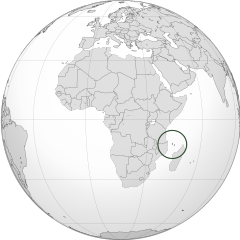
English: Orthographic map of the Comoros |
| Fecha | |
| Fuente | Obra propio |
| Outor | Spesh531 |
| Other versions |
Derivative works of this file: Africa (orthographic projection).svg .svg) |
.svg)
.svg)
.svg)
.svg)
.svg)
.svg)
.svg)
.svg)
.svg)
.svg)
.svg)
.svg)
.svg)
.svg)
.svg)
.svg)
.svg)
.svg)
.svg)
.svg)
.svg)
.svg)
.svg)
.svg)
.svg)
.svg)
.svg)
.svg)
.svg)
.svg)
.svg)
.svg)
.svg)
.svg)
.svg)
.svg)
.svg)
.svg)
.svg)
.svg)
.svg)
.svg)
.svg)
.svg)
.svg)
.svg)
.svg)
.svg)
.svg)
.svg)
.svg)
.svg)
.svg)
.svg)
.svg)
.svg)
.svg)
.svg)
.svg)
.svg)
.svg)
.svg)
.svg)
.svg)
.svg)
.svg)
.svg)
.svg)
.svg)
.svg)
.svg)
.svg)
.svg)

.svg)

.svg)

.svg)
.svg)
.svg)
.svg)
.svg)
.svg)
.svg)


.svg)
.svg)
.svg)
.svg)
.svg)
.svg)
.svg)

.svg)
.svg)
.svg)
.svg)
.svg)
.svg)
.svg)
.svg)
.svg)

.svg)
.svg)
.svg)
.svg)
.svg)
.svg)
.svg)
_without_national_boundaries.svg)
.svg)
.svg)
.svg)
.svg)
.svg)
.svg)

.svg)
.svg)
.png)
.svg)
.svg)
.svg)
.svg)

.svg)
.svg)
.svg)
.svg)
.svg)
.svg)
.svg)
.svg)
.svg)
.svg)
.svg)

.svg)
.svg)
.svg)
.svg)
.svg)
.svg)
.svg)
.svg)
.svg)

.svg)
.svg)

.svg)
.svg)
.svg)
.svg)
.svg)
.svg)
.svg)
.svg)
.svg)
.svg)
.svg)
.svg)
.svg)
.svg)
.svg)
.svg)
.svg)
.svg)
.svg)
.svg)
.svg)
.svg)
.svg)
.svg)
.svg)
.svg)
.svg)
_-_Crimea_disputed.svg)
.svg)
.svg)
.svg)
.svg)
.svg)
.svg)
.svg)
.svg)
.svg)
.svg)
.svg)
_political.svg)
.svg)
.svg)
.svg)
.svg)
_-_Crimea_disputed_-_no_borders.svg)
.svg)
.svg)
.svg)
.svg)
.svg)
.svg)
.svg)
.svg)
.svg)
.svg)
.svg)

.svg)
.svg)
.svg)

.png)
.svg)
.svg)
.svg)
.svg)
.svg)
.svg)
.svg)
.svg)
.svg)
.svg)
.svg)
.svg)
.svg)
.svg)
.svg)
.svg)
.svg)
.svg)
.svg)
.svg)
.svg)
.svg)
.svg)
.svg)
.svg)
.svg)
.svg)
.svg)
.svg)
.svg)
.svg)
.svg)
.svg)
.svg)
.png)
.svg)
.svg)
.svg)
_(orthographic_projection).png)
.svg)
| Camera location | | View this and other nearby images on: OpenStreetMap |
|---|
.svg¶ms=000.000000_N_0015.000000_E_globe:Earth_type:camera_type:satellite_&language=pap)
Lisensia
I, the copyright holder of this work, hereby publish it under the following licenses:
E fail akí tin lisensia Creative Commons Attribution-Share Alike 3.0 Unported.
- Bo ta liber:
- pa kompartí – pa kopia, distribuí i transmití e obra
- pa rekombiná – pa adaptá e obra
- Di akuerdo ku e próksimo kondishonnan:
- atribushon – Bo mester duna krédito na e outor, duna un lenk na e lisensia, i indiká si a hasi kambio. Bo por hasi esei na kualke manera rasonabel, perono na manera ku por sugerí ku esun ku ta otorgá e lisensia ta respaldá abo òf bo uzo.
- kompartí meskos – Si bo meskla, transfrmáòf modifiká e obra bo mester distribuí bo kontribushonnan bou di [mes lisensia https://creativecommons.org/share-your-work/licensing-considerations/compatible-licenses òf unu kompatibel] ku esun original.

|
Ta pèrmití kopia, distribuí i/òf modifiká e dokumento akí segun e GNU Free Documentation License, Vershon 1.2 òf kualke vershon mas resien publiká pa Free Software Foundation; sin Sekshon Invariante, sin teksto Front-Cover, i sin teksto Back-Cover. Un ehemplar di e lisensia ta inkluí den e sekshon yamá Lisensia di Dokumentashon Liber GNU. |
Bo por skohe e lisensia preferí.
Historia di fail
Klek riba un fecha/ora pa mira e fail, manera e tabata na e momentu ei.
| Fecha/Ora | Miniatura | Dimenshonnan | Usuario | Komentario | |
|---|---|---|---|---|---|
| aktual | 16:28, 29 yüni 2012 | | 550 × 550 (185 KB) | Spesh531 | == {{int:filedesc}} == {{Information |Description={{en|1=Orthographic map of the Comoros}} |Source={{own}} |Author=Spesh531 |Date=2012-06-29 |Permission= |other_versions={{DerivativeVersions|Africa (orthographic projection).svg}} {{Gr... |
Uso di fail
E próksimo page uses ta uza e fail akí:
Uso global di fail
E próksimo otro wikinan ta usa e fail akí
- Uso na ar.wikipedia.org
- Uso na arz.wikipedia.org
- Uso na ast.wikipedia.org
- Uso na avk.wikipedia.org
- Uso na az.wikipedia.org
- Uso na bg.wikipedia.org
- Uso na bi.wikipedia.org
- Uso na ca.wikipedia.org
- Uso na cdo.wikipedia.org
- Uso na ce.wikipedia.org
- Uso na chr.wikipedia.org
- Uso na cs.wikipedia.org
- Uso na dag.wikipedia.org
- Uso na de.wikivoyage.org
- Uso na diq.wikipedia.org
- Uso na el.wikipedia.org
- Uso na en.wikipedia.org
- Uso na en.wikinews.org
- Uso na es.wikipedia.org
- Uso na eu.wikipedia.org
- Uso na fa.wikivoyage.org
- Uso na fi.wikivoyage.org
- Uso na fo.wikipedia.org
- Uso na fr.wikipedia.org
- Uso na fr.wikinews.org
- Uso na ga.wikipedia.org
- Uso na gcr.wikipedia.org
- Uso na gl.wikipedia.org
- Uso na gn.wikipedia.org
- Uso na hak.wikipedia.org
- Uso na ha.wikipedia.org
- Uso na he.wikipedia.org
- Uso na ht.wikipedia.org
- Uso na ia.wikipedia.org
- Uso na id.wikipedia.org
- Uso na ie.wikipedia.org
- Uso na incubator.wikimedia.org
Mira mas uzo global di e fail akí.
.svg)
.svg)