
File:Curacao-CIA WFB Map.png
No tin resolushon mas mihó.
Curacao-CIA_WFB_Map.png (325 × 349 pixel, tamaño di fail: 11 KB, MIME type: image/png)
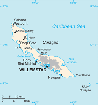
Resúmen
| Deskripshon |
English: Map of Curaçao from the 2010-10-22 revision of the World Factbook |
| Fecha | |
| Fuente | World Factbook website |
| Outor | Directorate of Intelligence, CIA |
Lisensia
This image is in the public domain because it contains materials that originally came from the United States Central Intelligence Agency's World Factbook.
|
 |
Historia di fail
Klek riba un fecha/ora pa mira e fail, manera e tabata na e momentu ei.
| Fecha/Ora | Miniatura | Dimenshonnan | Usuario | Komentario | |
|---|---|---|---|---|---|
| aktual | 11:13, 23 mei 2018 | | 325 × 349 (11 KB) | Ras67 | cropped, opt. |
| 11:21, 23 òktober 2010 |  | 330 × 353 (13 KB) | Hoshie | {{Information |Description= Map of {{w|Curaçao}} from the 2010-10-22 revision of the World Factbook |Source= [https://www.cia.gov/library/publications/the-world-factbook/maps/maptemplate_cc.html World Factbook website] |Date= 2010-10-22 |Author= Director |
Uso di fail
No tin página ku ta uza e fail akí.
Uso global di fail
E próksimo otro wikinan ta usa e fail akí
- Uso na als.wikipedia.org
- Uso na ast.wikipedia.org
- Uso na ba.wikipedia.org
- Uso na be-tarask.wikipedia.org
- Uso na br.wikipedia.org
- Uso na ca.wikipedia.org
- Uso na cs.wikipedia.org
- Uso na de.wikipedia.org
- Uso na en.wikipedia.org
- Uso na es.wikipedia.org
- Uso na eu.wikipedia.org
- Uso na fi.wikipedia.org
- Uso na frr.wikipedia.org
- Uso na ga.wikipedia.org
- Uso na gl.wikipedia.org
- Uso na he.wikipedia.org
- Uso na hu.wikipedia.org
- Uso na id.wikipedia.org
- Uso na incubator.wikimedia.org
- Uso na io.wikipedia.org
- Uso na ja.wikipedia.org
- Uso na ms.wikipedia.org
- Uso na mt.wikipedia.org
- Uso na nn.wikipedia.org
- Uso na no.wikipedia.org
- Uso na pl.wikipedia.org
- Uso na pl.wiktionary.org
- Uso na ru.wikipedia.org
- Uso na sl.wikipedia.org
- Uso na sw.wikipedia.org
- Uso na ta.wikipedia.org
- Uso na th.wikipedia.org
- Uso na to.wikipedia.org
- Uso na tt.wikipedia.org
- Uso na uk.wikipedia.org
- Uso na ur.wikipedia.org
- Uso na vi.wikipedia.org
Mira mas uzo global di e fail akí.