
File:East Germany 1956-1990.svg

Size of this PNG preview of this SVG file: 450 × 456 pixels. Otro resolushon: 237 × 240 pixels | 474 × 480 pixels | 758 × 768 pixels | 1,011 × 1,024 pixels | 2,021 × 2,048 pixels.
Fail original (Fail SVG, nominalmente 450x456 pixel, tamaño di fail: 474 KB)
Resúmen


.svg)
.svg)
.svg)
.svg)
.svg)


.svg)
.svg)
.svg)


.png)
.png)


.svg)


.svg)

.svg)


.svg)
.svg)
.svg)
.svg)


.svg)
.png)


.svg)


.svg)
.svg)


.svg)


.svg)


.svg)
.svg)
.svg)
.svg)
.svg)
.svg)
.svg)
_cropped.svg)
.svg)
.svg)
.svg)
.svg)
.svg)
.svg)
.svg)
.svg)
.svg)
.svg)
.svg)
.svg)
.svg)
.svg)
.svg)
.svg)
.svg)
.svg)
.svg)
.svg)
.svg)
.svg)
.svg)
.svg)
.svg)
.svg)
.svg)
.svg)
.svg)
.svg)
.svg)
.svg)
.svg)
.svg)
.svg)
.svg)
.svg)
.svg)
.svg)
.svg)
.svg)
.svg)
.svg)
.svg)
.svg)
| This is a retouched picture, which means that it has been digitally altered from its original version. The original can be viewed here: Blank map of Europe 1956-1990.svg:
|
Lisensia
I, the copyright holder of this work, hereby publish it under the following license:
E fail akí tin lisensia Creative Commons Attribution-Share Alike 3.0 Unported.
- Bo ta liber:
- pa kompartí – pa kopia, distribuí i transmití e obra
- pa rekombiná – pa adaptá e obra
- Di akuerdo ku e próksimo kondishonnan:
- atribushon – Bo mester duna krédito na e outor, duna un lenk na e lisensia, i indiká si a hasi kambio. Bo por hasi esei na kualke manera rasonabel, perono na manera ku por sugerí ku esun ku ta otorgá e lisensia ta respaldá abo òf bo uzo.
- kompartí meskos – Si bo meskla, transfrmáòf modifiká e obra bo mester distribuí bo kontribushonnan bou di [mes lisensia https://creativecommons.org/share-your-work/licensing-considerations/compatible-licenses òf unu kompatibel] ku esun original.
Original upload log
This image is a derivative work of the following images:
- File:Blank_map_of_Europe_1956-1990.svg licensed with Cc-by-sa-3.0
- 2011-10-30T04:43:42Z Alphathon 450x456 (485146 Bytes) == {{int:filedesc}} == {{Information |Description={{en|Blank map of Europe showing national borders as they stood from 1956-1990.}} |Source=*[[:File:Blank_map_of_Europe.svg|]] |Date=2011-10-30 04:42 (UTC) |Author=*[[:File:Bla
Historia di fail
Klek riba un fecha/ora pa mira e fail, manera e tabata na e momentu ei.
| Fecha/Ora | Miniatura | Dimenshonnan | Usuario | Komentario | |
|---|---|---|---|---|---|
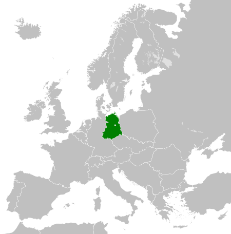
| aktual | 00:33, 26 novèmber 2011 | | 450 × 456 (474 KB) | StalwartUK | == {{int:filedesc}} == {{Information |Description={{en|Map of the East Germany (German Democratic Republic) as it was from 1949-1990. Surrounding countries accurate from 1956-1990.}} |Source=*[[:File:Blank_map_of_Europe_1956-1990.svg| |
Uso di fail
E próksimo page uses ta uza e fail akí:
Uso global di fail
E próksimo otro wikinan ta usa e fail akí
- Uso na af.wikipedia.org
- Uso na am.wikipedia.org
- Uso na an.wikipedia.org
- Uso na ar.wikipedia.org
- Uso na ast.wikipedia.org
- Uso na azb.wikipedia.org
- Uso na az.wikipedia.org
- Uso na ba.wikipedia.org
- Uso na be.wikipedia.org
- Uso na bs.wikipedia.org
- Uso na ca.wikipedia.org
- Uso na ce.wikipedia.org
- Uso na cs.wikipedia.org
- Uso na de.wikipedia.org
- Uso na de.wiktionary.org
- Uso na diq.wikipedia.org
- Uso na el.wikipedia.org
- Uso na en.wikipedia.org
- Uso na en.wiktionary.org
- Uso na eo.wikipedia.org
- Uso na es.wikipedia.org
- Uso na es.wiktionary.org
- Uso na eu.wikipedia.org
- Uso na ext.wikipedia.org
- Uso na fa.wikipedia.org
- Uso na fi.wikipedia.org
- Uso na fr.wikipedia.org
- Uso na fr.wiktionary.org
- Uso na ga.wikipedia.org
- Uso na gd.wikipedia.org
- Uso na gl.wikipedia.org
- Uso na gv.wikipedia.org
- Uso na he.wikipedia.org
- Uso na hi.wikipedia.org
- Uso na hr.wikipedia.org
- Uso na hr.wiktionary.org
- Uso na hsb.wikipedia.org
- Uso na hu.wikipedia.org
- Uso na hy.wikipedia.org
- Uso na ia.wikipedia.org
- Uso na id.wikipedia.org
- Uso na is.wikipedia.org
- Uso na it.wikipedia.org
Mira mas uzo global di e fail akí.