
File:Erinnyis ello MHNT dos male.jpg

Tamaño di bista previo: 800 × 528 pixels. Otro resolushon: 320 × 211 pixels | 640 × 422 pixels | 1,024 × 676 pixels | 1,280 × 845 pixels | 2,560 × 1,690 pixels | 5,376 × 3,548 pixels.
Fail original (5,376 × 3,548 pixel, tamaño di fail: 6.72 MB, MIME type: image/jpeg)
|
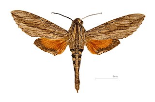
Erinnyis ello Linnaeus, 1758 |
| Photographer | ||||||||||||||||||||||||
| Deskripshon |
Deutsch: Erinnyis ello - Dorsalansicht English: Erinnyis ello - Dorsal side Français : Erinnyis ello - Face dorsale |
|||||||||||||||||||||||
| Género | Male organism | |||||||||||||||||||||||
| location of discovery | ||||||||||||||||||||||||
| Fecha | 21 òktober 2012 | |||||||||||||||||||||||
| Collection |
|
|||||||||||||||||||||||
| Accession number |
MHNT.CUT.2011.0.164 |
|||||||||||||||||||||||
| Fuente | Obra propio | |||||||||||||||||||||||
| Pèrmit (Ta re-utilisá e fail akí) |
I, the copyright holder of this work, hereby publish it under the following license: This file is licensed under the Creative Commons Attribution-Share Alike 4.0 International license.
|
|||||||||||||||||||||||
| Other versions |
| |||||||||||||||||||||||
| Processing | Focus stack of 3 pictures translate | |||||||||||||||||||||||


| Camera location | | View this and other nearby images on: OpenStreetMap |
|---|

|
This document was made as part of the Projet Phoebus.
|
Historia di fail
Klek riba un fecha/ora pa mira e fail, manera e tabata na e momentu ei.
| Fecha/Ora | Miniatura | Dimenshonnan | Usuario | Komentario | |
|---|---|---|---|---|---|
| aktual | 09:17, 21 òktober 2012 | | 5,376 × 3,548 (6.72 MB) | Archaeodontosaurus | {{Information |Description ={{en|1=x}} |Source ={{own}} |Author =Archaeodontosaurus |Date = |Permission = |other_versions = }} |
Uso di fail
E próksimo page uses ta uza e fail akí:
Uso global di fail
E próksimo otro wikinan ta usa e fail akí
- Uso na arz.wikipedia.org
- Uso na ast.wikipedia.org
- Uso na be.wikipedia.org
- Uso na de.wikipedia.org
- Uso na en.wikipedia.org
- Callionima calliomenae
- Callionima falcifera
- Callionima nomius
- Erinnyis alope
- Erinnyis crameri
- Erinnyis ello
- Erinnyis lassauxii
- Erinnyis obscura
- Erinnyis yucatana
- Hemeroplanes triptolemus
- Isognathus rimosa
- Erinnyis
- Callionima
- Madoryx oiclus
- Madoryx pseudothyreus
- Pachylia darceta
- Pachylia ficus
- Perigonia jamaicensis
- Perigonia lusca
- Aellopos ceculus
- Stolidoptera tachasara
- Aellopos clavipes
- Aellopos fadus
- Aellopos titan
- Cautethia grotei
- Cautethia spuria
- Enyo gorgon
- Enyo lugubris
- Enyo ocypete
- Hemaris diffinis
- Hemaris tityus
- Aellopos
- Cephonodes hylas
- Hemaris fuciformis
- Hemaris thetis
- Hemaris gracilis
- Aellopos tantalus
- Aellopos blaini
- Dilophonotini
- Protaleuron
- Stolidoptera
- Cephonodes
- Unzela
- Oryba
- Phryxus caicus
- Perigonia
Mira mas uzo global di e fail akí.