
File:ISS-20 Caribbean island of Hispaniola from the ISS.jpg
Tamaño di bista previo: 800 × 532 pixels. Otro resolushon: 320 × 213 pixels | 640 × 426 pixels | 1,024 × 681 pixels | 1,280 × 852 pixels | 2,560 × 1,703 pixels | 4,256 × 2,832 pixels.
Fail original (4,256 × 2,832 pixel, tamaño di fail: 1.17 MB, MIME type: image/jpeg)
Resúmen
| Deskripshon |
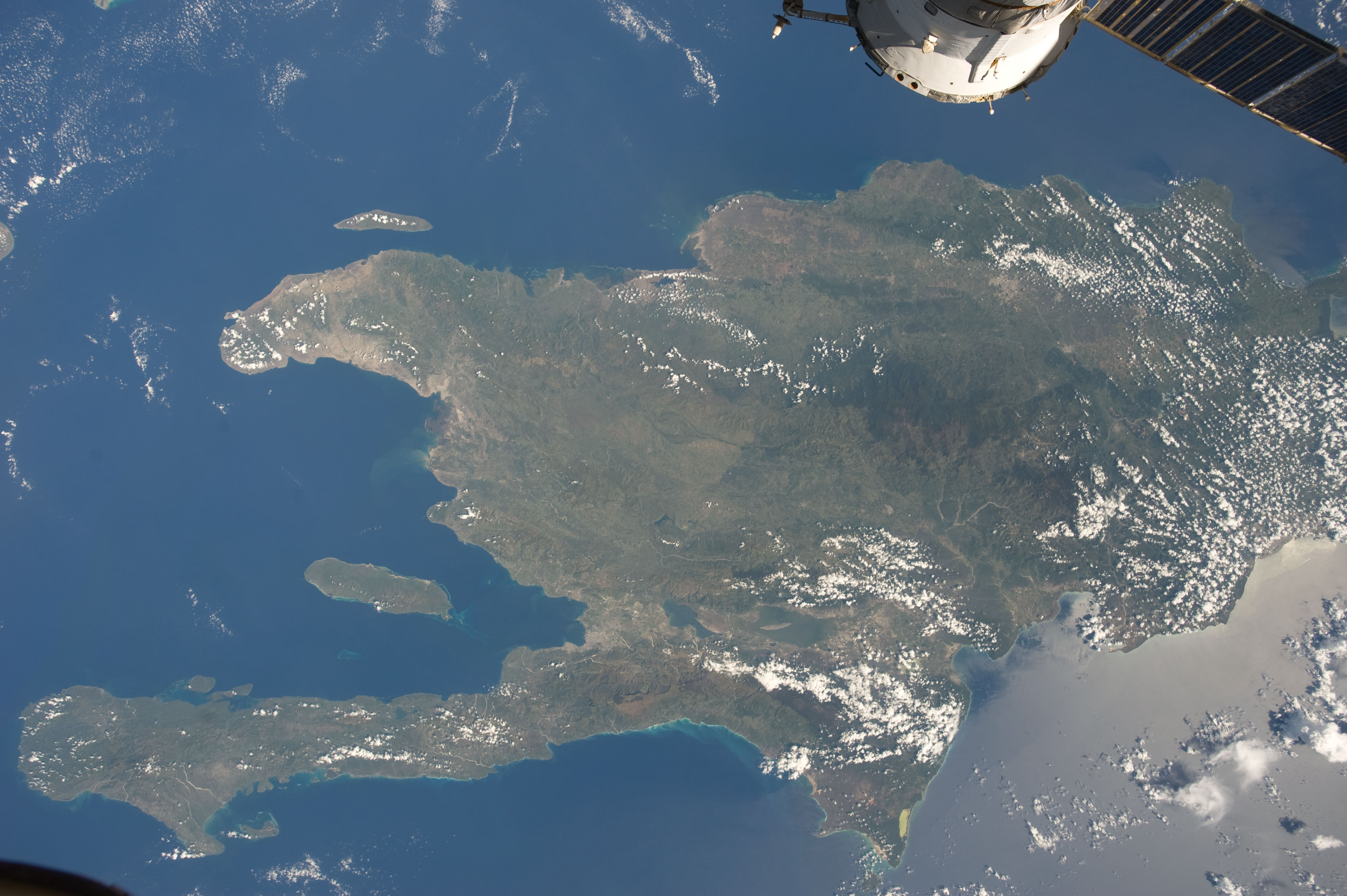
English: A view of the Caribbean island of Hispaniola from the International Space Station. This island is comprised of Haiti (in the center left of the image) and the Dominican Republic and is part of the Greater Antilles island chain which lies along the geological border of the North America Plate and the Caribbean Plate. A major fault line in the region, Enriquillo-Plantain Garden Fault, runs along the longer peninsula, in the foreground, and just south of Port-au-Prince. Part of a docked Russian spacecraft can be seen in the foreground. The epicenter of the disastrous 2010 earthquake occurred near this fault. This image was taken by the Expedition 20 crew on the International Space Station on Sept. 28, 2009 using a 25 mm lens setting. |
| Fecha | |
| Fuente | http://spaceflight.nasa.gov/gallery/images/station/crew-20/html/iss020e043301.html |
| Outor | NASA/Expedition 20 crew |
| Other versions |
This image or video was catalogued by Johnson Space Center of the United States National Aeronautics and Space Administration (NASA) under Photo ID: ISS020-E-043301. This tag does not indicate the copyright status of the attached work. A normal copyright tag is still required. See Commons:Licensing. Other languages:
|
Lisensia
| This file is in the public domain in the United States because it was solely created by NASA. NASA copyright policy states that "NASA material is not protected by copyright unless noted". (See Template:PD-USGov, NASA copyright policy page or JPL Image Use Policy.) | ||
 |
Warnings:
|
Historia di fail
Klek riba un fecha/ora pa mira e fail, manera e tabata na e momentu ei.
| Fecha/Ora | Miniatura | Dimenshonnan | Usuario | Komentario | |
|---|---|---|---|---|---|
| aktual | 20:18, 22 yüni 2012 | | 4,256 × 2,832 (1.17 MB) | Ras67 | {{Information |Description={{en|1=A view of the Caribbean island of Hispaniola from the International Space Station. This island is comprised of Haiti (in the center left of the image) and the Dominican Republic and is part of the Greater Antilles isla... |
Uso di fail
E próksimo page uses ta uza e fail akí:
Uso global di fail
E próksimo otro wikinan ta usa e fail akí
- Uso na ar.wikipedia.org
- Uso na ast.wikipedia.org
- Uso na az.wikipedia.org
- Uso na ba.wikipedia.org
- Uso na ca.wikipedia.org
- Uso na ceb.wikipedia.org
- Uso na cy.wikipedia.org
- Uso na de.wikipedia.org
- Uso na es.wikipedia.org
- Uso na eu.wikipedia.org
- Uso na fi.wiktionary.org
- Uso na fr.wikivoyage.org
- Uso na ga.wikipedia.org
- Uso na hsb.wikipedia.org
- Uso na ht.wikipedia.org
- Uso na hy.wikipedia.org
- Uso na ia.wikipedia.org
- Uso na lb.wikipedia.org
- Uso na no.wikipedia.org
- Uso na pl.wikipedia.org
- Uso na pnb.wikipedia.org
- Uso na ro.wikipedia.org
- Uso na sv.wikipedia.org
- Uso na tg.wikipedia.org
- Uso na uk.wikipedia.org
- Uso na uz.wikipedia.org
- Uso na vec.wikipedia.org
- Uso na www.wikidata.org