File:Krakatoa evolution map-fr.gif

Page contents not supported in other languages.
Di Wikipedia, e ensiklopedia liber

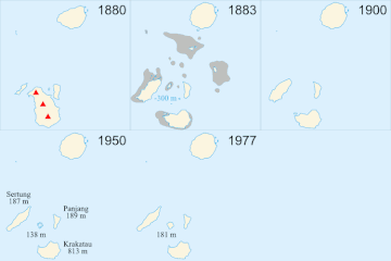
Krakatoa_evolution_map-fr.gif(250 × 250 pixel, tamaño di fail: 41 KB, MIME type: image/gif, looped, 14 frames, 37 s)

E fail akí ta di Wikimedia Commons i por us'é den otro proyekto. E deskripshon riba su página di deskripshon di fail ta indiká mas abou.

Resúmen

Deskripshon
English: Evolution map in French of the Krakatoa's archipelago (Indonesia), between 1880 and 2005. The main eruption was in 1883.
Français : Carte de l'évolution de l'archipel du Krakatoa (Indonésie), entre 1880 et 2005. L'éruption principale date de 1883.
Español: Mapa, en francés, de la evolución de el archipiélago Krakatoa (Indonesia), entre 1880 y 2005. La erupción principal fué en 1883.
Italiano: Mappa, in francese, dell'evoluzione dell'arcipelago di Krakatoa (Indonesia), tra il 1880 e il 2005. L'eruzione principale avvenne nel 1883.
Fecha
Fuente

travail personnel. Sources :

Outor Sémhur
Other versions Derivative works of this file:  Krakatoa evolution map-en.gif
Camera location6° 06′ 07.2″ S, 105° 25′ 22.8″ E  Heading=1° Kartographer map based on OpenStreetMap.View this and other nearby images on: OpenStreetMapinfo

Lisensia

I, the copyright holder of this work, hereby publish it under the following licenses:
GNU head Ta pèrmití kopia, distribuí i/òf modifiká e dokumento akí segun e GNU Free Documentation License, Vershon 1.2 òf kualke vershon mas resien publiká pa Free Software Foundation; sin Sekshon Invariante, sin teksto Front-Cover, i sin teksto Back-Cover. Un ehemplar di e lisensia ta inkluí den e sekshon yamá Lisensia di Dokumentashon Liber GNU.
w:en:Creative Commons
atribushon kompartí meskos
This file is licensed under the Creative Commons Attribution-Share Alike 3.0 Unported, 2.5 Generic, 2.0 Generic and 1.0 Generic license.
Bo ta liber:
  • pa kompartí – pa kopia, distribuí i transmití e obra
  • pa rekombiná – pa adaptá e obra
Di akuerdo ku e próksimo kondishonnan:
  • atribushon – Bo mester duna krédito na e outor, duna un lenk na e lisensia, i indiká si a hasi kambio. Bo por hasi esei na kualke manera rasonabel, perono na manera ku por sugerí ku esun ku ta otorgá e lisensia ta respaldá abo òf bo uzo.
  • kompartí meskos – Si bo meskla, transfrmáòf modifiká e obra bo mester distribuí bo kontribushonnan bou di [mes lisensia https://creativecommons.org/share-your-work/licensing-considerations/compatible-licenses òf unu kompatibel] ku esun original.
Bo por skohe e lisensia preferí.

Captions

Add a one-line explanation of what this file represents

Items portrayed in this file

ta portretá

6°6'7"S, 105°25'23"E

heading ingles: 1 degree

media type ingles

image/gif

Historia di fail

Klek riba un fecha/ora pa mira e fail, manera e tabata na e momentu ei.

Fecha/OraMiniaturaDimenshonnanUsuarioKomentario
aktual08:33, 24 aprel 2008Miniatura di e vershon di 08:33, 24 aprel 2008250 × 250 (41 KB)Sémhur== Description == {{Information |Description= {{en|Evolution map in French of the Krakatoa's archipelago (Indonesia), between 1880 and 2005. The main eruption was in 1883.}} {{fr|Carte de l'évolution de l'archipel du [[:fr:Krakatoa|Kraka

E próksimo page uses ta uza e fail akí:

Uso global di fail

E próksimo otro wikinan ta usa e fail akí