
File:Lena watershed.png
No tin resolushon mas mihó.
Lena_watershed.png (500 × 500 pixel, tamaño di fail: 138 KB, MIME type: image/png)
Resúmen
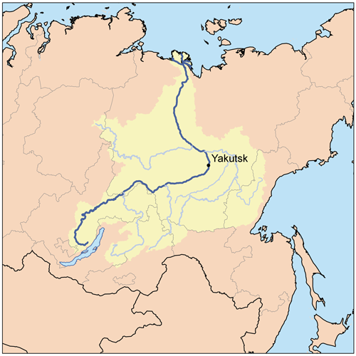
| Deskripshon | This is a map of the Lena River Watershed. I, Karl Musser, created it based on USGS data. |
| Fecha | 11 aprel 2006 (original upload date) |
| Fuente | No machine-readable source provided. Own work assumed (based on copyright claims). |
| Outor | No machine-readable author provided. Kmusser assumed (based on copyright claims). |
Lisensia
I, the copyright holder of this work, hereby publish it under the following license:
This file is licensed under the Creative Commons Attribution-Share Alike 2.5 Generic license.
- Bo ta liber:
- pa kompartí – pa kopia, distribuí i transmití e obra
- pa rekombiná – pa adaptá e obra
- Di akuerdo ku e próksimo kondishonnan:
- atribushon – Bo mester duna krédito na e outor, duna un lenk na e lisensia, i indiká si a hasi kambio. Bo por hasi esei na kualke manera rasonabel, perono na manera ku por sugerí ku esun ku ta otorgá e lisensia ta respaldá abo òf bo uzo.
- kompartí meskos – Si bo meskla, transfrmáòf modifiká e obra bo mester distribuí bo kontribushonnan bou di [mes lisensia https://creativecommons.org/share-your-work/licensing-considerations/compatible-licenses òf unu kompatibel] ku esun original.
Historia di fail
Klek riba un fecha/ora pa mira e fail, manera e tabata na e momentu ei.
| Fecha/Ora | Miniatura | Dimenshonnan | Usuario | Komentario | |
|---|---|---|---|---|---|
| aktual | 19:59, 17 sèptèmber 2007 | | 500 × 500 (138 KB) | Kmusser | added tributaries, upped resolution |
| 17:01, 11 aprel 2006 |  | 300 × 300 (18 KB) | Kmusser | This is a map of the Lena River Watershed. I, Karl Musser, created it based on USGS data. {{GFDL}} Category:Maps of rivers |
Uso di fail
E próksimo page uses ta uza e fail akí:
Uso global di fail
E próksimo otro wikinan ta usa e fail akí
- Uso na af.wikipedia.org
- Uso na ast.wikipedia.org
- Uso na avk.wikipedia.org
- Teza:AldanKuksa
- Teza:LenaBost
- Teza:VilyuyKuksa
- Aldan (kuksa)
- Allax-Yun (kuksa)
- Ameditci (kuksa)
- Amga (kuksa)
- Axtaranda (kuksa)
- Yudoma (kuksa)
- Vilyuy (kuksa)
- Ulaxan-Botuobuya (kuksa)
- Ungra (kuksa)
- Utcur (kuksa)
- Tyukyan (kuksa)
- Tyung (kuksa)
- Tiri (kuksa)
- Tompo (kuksa)
- Tcona (kuksa)
- Tculman (kuksa)
- Timpton (kuksa)
- Tcilli (kuksa)
- Tatta (kuksa)
- Tangnari (kuksa)
- Gonam (kuksa)
- Igiatta (kuksa)
- Lena
- Marxa (kuksa)
- Maya (kuksa)
- Morkoka (kuksa)
- Notora (kuksa)
- Otcuguy-Botuobuya (kuksa)
- Olyokma (kuksa)
- Teza:OlyokmaKuksa
- Tungir (kuksa)
- Nyukja (kuksa)
- Tcara (kuksa)
- Vitim (kuksa)
- Kalar (kuksa)
- Kalakan (kuksa)
- Karenga (kuksa)
- Yumurtcen (kuksa)
- Tsipa (kuksa)
- Teza:VitimKuksa
- Kuanda (kuksa)
- Mamakan (kuksa)
- Mama (kuksa)
- Muya (kuksa)
- Zaza (kuksa)
Mira mas uzo global di e fail akí.