
File:Mapa administrativo de Chile.png

Tamaño di bista previo: 366 × 598 pixels. Otro resolushon: 147 × 240 pixels | 293 × 480 pixels | 896 × 1,465 pixels.
Fail original (896 × 1,465 pixel, tamaño di fail: 181 KB, MIME type: image/png)

|
This image (or all images in this category) uses inside labels or attached captions in a specific script or language and should be converted to a language neutral form. This would allow its use in all Wikimedia projects and, more importantly, all Wikimedia languages.
|
| Deskripshon |
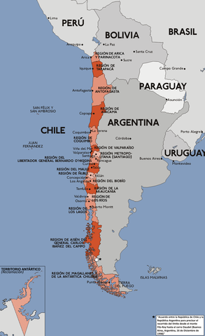
Español: Mapa con la división administrativa de la República de Chile.
Deutsch: Darstellung zeigt die Verwaltungsgliederung von Chile.
English: This diagram shows the administrative districts of Chile.
Français : Ce diagramme montre les districts administratifs du Chili. |
||||||||
| Fecha | |||||||||
| Fuente | Karte chile verwaltungsgliederung.png | ||||||||
| Outor | Sansculotte (original), B1mbo | ||||||||
| Pèrmit (Ta re-utilisá e fail akí) |
|

Historia di fail
Klek riba un fecha/ora pa mira e fail, manera e tabata na e momentu ei.
| Fecha/Ora | Miniatura | Dimenshonnan | Usuario | Komentario | |
|---|---|---|---|---|---|
| aktual | 17:56, 22 febrüari 2018 | | 896 × 1,465 (181 KB) | Janitoalevic | . |
| 17:34, 22 febrüari 2018 |  | 896 × 1,465 (181 KB) | Janitoalevic | Added Ñuble Region | |
| 18:33, 2 desèmber 2017 |  | 896 × 1,465 (171 KB) | Janitoalevic | Fixed borders | |
| 22:47, 22 yüli 2011 |  | 896 × 1,465 (150 KB) | Ras67 | cropped | |
| 18:40, 9 febrüari 2008 |  | 900 × 1,469 (209 KB) | Jorge | Corregí ortografía {{Convert to international}} {{es|Mapa con la división administrativa (1979 - 2006) de la República de Chile. Este mapa está traducido al español en base a Image:Karte chile verwaltungsgliederung.png, crea | |
| 03:28, 3 òktober 2007 |  | 900 × 1,469 (237 KB) | B1mbo | Agregando nuevas regiones | |
| 22:29, 28 òktober 2006 |  | 900 × 1,469 (231 KB) | B1mbo | ||
| 22:07, 28 òktober 2006 |  | 900 × 1,469 (231 KB) | B1mbo | Agregado el Territorio Antártico (reclamación) | |
| 17:33, 4 sèptèmber 2006 |  | 900 × 1,469 (267 KB) | Gonzaloluengo | ||
| 22:35, 25 yanüari 2006 |  | 900 × 1,469 (190 KB) | B1mbo | de:Bild:Karte chile verwaltungsgliederung.png {{Spanish}} Mapa con la división administrativa (1979 - 2006) de la República de Chile. Este mapa está traducido al español en base a Image:Karte chile verwaltungsgliederung.png, |
Uso di fail
E próksimo page uses ta uza e fail akí:
Uso global di fail
E próksimo otro wikinan ta usa e fail akí
- Uso na ace.wikipedia.org
- Uso na af.wikipedia.org
- Uso na an.wikipedia.org
- Uso na awa.wikipedia.org
- Uso na ay.wikipedia.org
- Uso na azb.wikipedia.org
- Uso na bat-smg.wikipedia.org
- Uso na bcl.wikipedia.org
- Uso na bh.wikipedia.org
- Uso na bi.wikipedia.org
- Uso na bpy.wikipedia.org
- Uso na bs.wikipedia.org
- Uso na cbk-zam.wikipedia.org
- Uso na ceb.wikipedia.org
- Uso na ch.wikipedia.org
- Uso na crh.wikipedia.org
- Uso na cv.wikipedia.org
- Uso na de.wikipedia.org
- Uso na diq.wikipedia.org
- Uso na dsb.wikipedia.org
- Uso na ee.wikipedia.org
- Uso na el.wikipedia.org
- Uso na en.wikibooks.org
- Uso na eo.wikipedia.org
- Uso na es.wikipedia.org
- Portal:Lingüística
- Anexo:Puntos extremos de Chile
- Anexo:Gentilicios de Chile
- Anexo:Regiones de Chile por superficie
- Anexo:Especies de coníferas nativas de Chile
- Anexo:Sitios relevantes para la observación de aves en Chile
- Usuario:Sgonzalezb/Reyno de Chile
- Anexo:Regiones de Chile por población
- Anexo:Vertebrados introducidos en Chile
- Vertebrados introducidos en Chile
- Anexo:Regiones de Chile por densidad
- Uso na es.wikibooks.org
- Uso na eu.wikipedia.org
- Uso na fiu-vro.wikipedia.org
- Uso na frp.wikipedia.org
- Uso na fur.wikipedia.org
- Uso na fy.wikipedia.org
- Uso na ga.wikipedia.org
- Uso na gd.wikipedia.org
- Uso na got.wikipedia.org
- Uso na gu.wikipedia.org
- Uso na hr.wikipedia.org
- Uso na hu.wikipedia.org
Mira mas uzo global di e fail akí.