
File:Tanzania - Location Map (2013) - TZA - UNOCHA.svg

Fail original (Fail SVG, nominalmente 250x250 pixel, tamaño di fail: 380 KB)
_-_TZA_-_UNOCHA.svg)
Resúmen
Lisensia
- Bo ta liber:
- pa kompartí – pa kopia, distribuí i transmití e obra
- pa rekombiná – pa adaptá e obra
- Di akuerdo ku e próksimo kondishonnan:
- atribushon – Bo mester duna krédito na e outor, duna un lenk na e lisensia, i indiká si a hasi kambio. Bo por hasi esei na kualke manera rasonabel, perono na manera ku por sugerí ku esun ku ta otorgá e lisensia ta respaldá abo òf bo uzo.
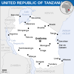
 This map is part of a collection of 216 free country maps, created by the UN Office for the Coordination of Humanitarian Affairs (OCHA), to be used in print, web or broadcast products.
The ReliefWeb Location Maps released here are maps that highlight a country, its capital, major populated places and the surrounding regions. Attribution Requirements
Using the map without modifications: ensure that the sources and the disclaimer are below the map. Credit as follows: "Credit: OCHA". For use with alteration: remove the OCHA logo and disclaimer following any modification to the map, but keep the data sources as mentioned below the map. Credit the modified map as follows: "Based on OCHA map". You are responsible for the content of your map. We are keen to receive your feedback and hear how you used OCHA's maps. We would be grateful if you would notify us by e-mail and share your work with us. UN Disclaimer
The designations employed and the presentation of material of this map do not imply the expression of any opinion whatsoever on the part of the Secretariat of the United Nations concerning the legal status of any country, territory, city or area or of its authorities or concerning the delimitation of its frontiers or boundaries. |

|
Textual information (e.g. timestamp) once visible in the image itself has been moved into the image metadata and/or image description page. This makes the image easier to reuse and more language-neutral, and makes the text easier to process and search for. Commons discourages placing visible textual information in images. All licenses accepted on Commons permit this type of modification as a derivative work.
If attribution information were removed and the image is not public domain, replace this tag with {{Attribution metadata from licensed image}}.
|
Historia di fail
Klek riba un fecha/ora pa mira e fail, manera e tabata na e momentu ei.
| Fecha/Ora | Miniatura | Dimenshonnan | Usuario | Komentario | |
|---|---|---|---|---|---|
| aktual | 00:55, 23 sèptèmber 2023 | | 250 × 250 (380 KB) | Berpihakdibalutkenetralan | File uploaded using svgtranslate tool (https://svgtranslate.toolforge.org/). Added translation for id. |
| 20:30, 30 desèmber 2022 |  | 250 × 250 (380 KB) | Wikijahnn | File uploaded using svgtranslate tool (https://svgtranslate.toolforge.org/). Added translation for ca. | |
| 04:07, 19 novèmber 2022 |  | 250 × 250 (378 KB) | Pengetik-AM | File uploaded using svgtranslate tool (https://svgtranslate.toolforge.org/). Added translation for id. | |
| 10:59, 1 aprel 2016 |  | 250 × 250 (378 KB) | Wereldburger758 | Resized page to drawing. Removal watermark. Validation of image. | |
| 01:18, 8 mei 2014 |  | 254 × 254 (392 KB) | UN OCHA maps bot | == {{int:filedesc}} == {{Information |description={{en|1=Locator map of Tanzania.}} |date=2013 |source={{en|1=[http://reliefweb.int/map/united-republic-tanzania/united-republic-tanzania-location-map-2013 United Republic of Tanzania Lo... |
Uso di fail
No tin página ku ta uza e fail akí.
Uso global di fail
E próksimo otro wikinan ta usa e fail akí
- Uso na ban.wikipedia.org
- Uso na ca.wikipedia.org
- Uso na el.wikipedia.org
- Uso na en.wikipedia.org
- Uso na id.wikipedia.org
- Uso na incubator.wikimedia.org
- Uso na io.wikipedia.org
- Uso na lb.wikipedia.org
- Uso na pl.wikipedia.org
- Uso na simple.wikipedia.org
- Uso na si.wikipedia.org
_-_TZA_-_UNOCHA.svg)