
File:Tectonic plate boundaries.png
No tin resolushon mas mihó.
Tectonic_plate_boundaries.png (775 × 429 pixel, tamaño di fail: 83 KB, MIME type: image/png)
Resúmen
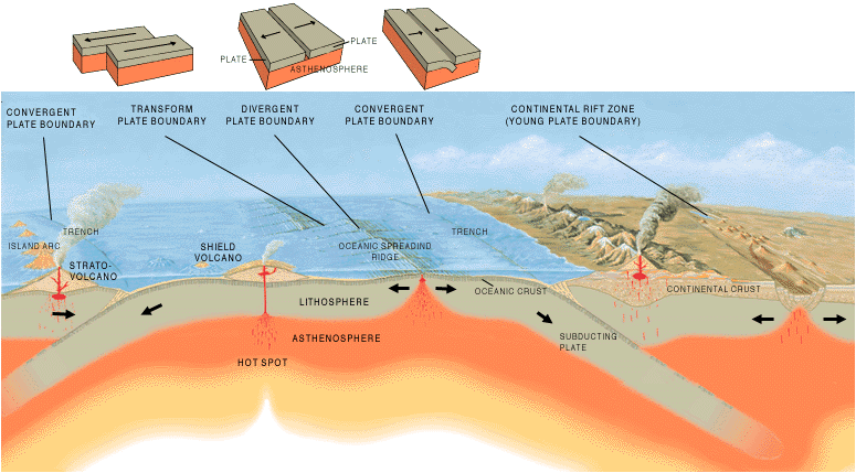
| Deskripshon | A cross section illustrating the main types of plate boundaries. |
| Fecha | |
| Fuente | [1] |
| Outor | Jose F. Vigil. USGS |
| Other versions |
Slovenian translation, Spanish version
[]
|


Lisensia
This image is in the public domain in the United States because it only contains materials that originally came from the United States Geological Survey, an agency of the United States Department of the Interior. For more information, see the official USGS copyright policy.
|
Historia di fail
Klek riba un fecha/ora pa mira e fail, manera e tabata na e momentu ei.
| Fecha/Ora | Miniatura | Dimenshonnan | Usuario | Komentario | |
|---|---|---|---|---|---|
| aktual | 15:40, 26 desèmber 2005 | | 775 × 429 (83 KB) | Merikanto~commonswiki | Illustration by Jose F. Vigil. USGS. [http://pubs.usgs.gov/gip/earthq1/plate.html] {{PD-USGov-Interior-USGS}} |
Uso di fail
E próksimo page uses ta uza e fail akí:
Uso global di fail
E próksimo otro wikinan ta usa e fail akí
- Uso na ar.wikipedia.org
- Uso na as.wikipedia.org
- Uso na az.wikipedia.org
- Uso na ba.wikipedia.org
- Uso na bg.wikipedia.org
- Uso na bs.wikipedia.org
- Uso na da.wikipedia.org
- Uso na de.wikipedia.org
- Uso na en.wikipedia.org
- Uso na en.wikibooks.org
- Uso na eo.wikipedia.org
- Uso na es.wikipedia.org
- Uso na eu.wikipedia.org
- Uso na fa.wikipedia.org
- Uso na fi.wikipedia.org
- Uso na fr.wikipedia.org
- Uso na ga.wikipedia.org
- Uso na he.wikipedia.org
- Uso na hi.wikipedia.org
- Uso na hu.wikipedia.org
- Uso na hy.wikipedia.org
- Uso na hyw.wikipedia.org
- Uso na id.wikipedia.org
- Uso na it.wikipedia.org
- Uso na it.wikibooks.org
- Uso na it.wikiversity.org
- Uso na ja.wikipedia.org
- Uso na ka.wikipedia.org
- Uso na kn.wikipedia.org
Mira mas uzo global di e fail akí.