
File:Belgian colonial empire.png

Tamaño di bista previo: 800 × 351 pixels. Otro resolushon: 320 × 140 pixels | 640 × 281 pixels | 1,425 × 625 pixels.
Fail original (1,425 × 625 pixel, tamaño di fail: 38 KB, MIME type: image/png)

|
File:Belgian colonial empire.svg is a vector version of this file. It should be used in place of this PNG file when not inferior.
File:Belgian colonial empire.png → File:Belgian colonial empire.svg
For more information, see Help:SVG. |
 |
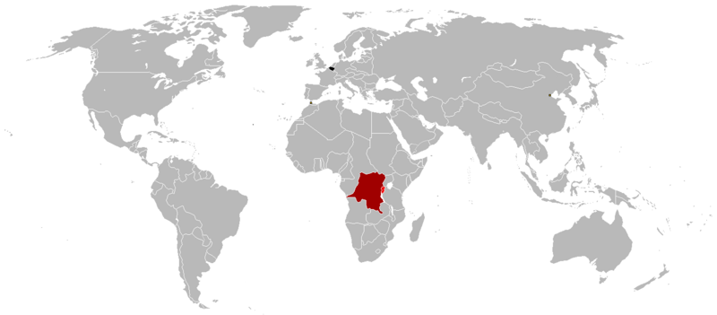
Resúmen
- Black = Belgium
- Dark red = Belgian Congo (1908-1960)
- Light red = Ruanda-Urundi (1916-1962)
- Yellow squares = Tientsin, China (concession zone) and Tanger, Morocco (international zone)
Lisensia
I, the copyright holder of this work, hereby publish it under the following license:

|
Ta pèrmití kopia, distribuí i/òf modifiká e dokumento akí segun e GNU Free Documentation License, Vershon 1.2 òf kualke vershon mas resien publiká pa Free Software Foundation; sin Sekshon Invariante, sin teksto Front-Cover, i sin teksto Back-Cover. Un ehemplar di e lisensia ta inkluí den e sekshon yamá Lisensia di Dokumentashon Liber GNU. |
| E fail akí tin lisensia Creative Commons Attribution-Share Alike 3.0 Unported. | ||
| ||
| This licensing tag was added to this file as part of the GFDL licensing update. |
Historia di fail
Klek riba un fecha/ora pa mira e fail, manera e tabata na e momentu ei.
| Fecha/Ora | Miniatura | Dimenshonnan | Usuario | Komentario | |
|---|---|---|---|---|---|
| aktual | 01:54, 16 yüli 2023 | | 1,425 × 625 (38 KB) | Randomastwritter | added jubaland |
| 01:34, 8 mart 2017 |  | 1,425 × 625 (48 KB) | Grachifan | adding missing belgiujm in black | |
| 14:07, 20 ougùstùs 2016 |  | 1,425 × 625 (38 KB) | The- | Better map | |
| 17:12, 17 ougùstùs 2016 |  | 1,357 × 628 (2.44 MB) | RVBatman32 | Reverted to version as of 17:10, 17 August 2016 (UTC) | |
| 17:11, 17 ougùstùs 2016 |  | 1,357 × 628 (2.44 MB) | RVBatman32 | Reverted to version as of 18:51, 4 June 2016 (UTC) Don't know why Iran was missing,reverted | |
| 17:10, 17 ougùstùs 2016 |  | 1,357 × 628 (2.44 MB) | RVBatman32 | Reverted to version as of 18:51, 4 June 2016 (UTC) | |
| 12:07, 31 yüli 2016 |  | 1,425 × 625 (38 KB) | The- | Better map | |
| 18:51, 4 yüni 2016 |  | 1,357 × 628 (2.44 MB) | Roxanna | Reverted to version as of 13:19, 11 January 2013 (UTC) Belgium! Not Netherlands! | |
| 12:03, 6 mei 2016 |  | 1,425 × 625 (38 KB) | The- | Better map | |
| 13:19, 11 yanüari 2013 |  | 1,357 × 628 (2.44 MB) | Roxanna | including International Zone of Tanger (same marked as Tientin) |
Uso di fail
No tin página ku ta uza e fail akí.
Uso global di fail
E próksimo otro wikinan ta usa e fail akí
- Uso na de.wikipedia.org
- Uso na es.wikipedia.org
- Uso na hy.wikipedia.org
- Uso na sk.wikipedia.org
- Uso na zh.wikipedia.org