
File:Conquista Hispania.svg

Size of this PNG preview of this SVG file: 800 × 547 pixels. Otro resolushon: 320 × 219 pixels | 640 × 438 pixels | 1,024 × 701 pixels | 1,280 × 876 pixels | 2,560 × 1,752 pixels | 950 × 650 pixels.
Fail original (Fail SVG, nominalmente 950x650 pixel, tamaño di fail: 1.07 MB)
Resúmen
| Deskripshon |
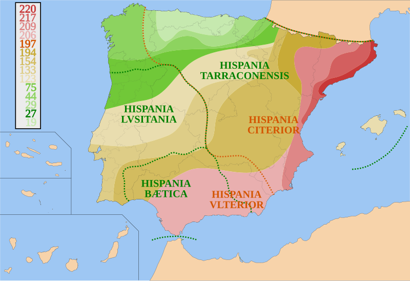
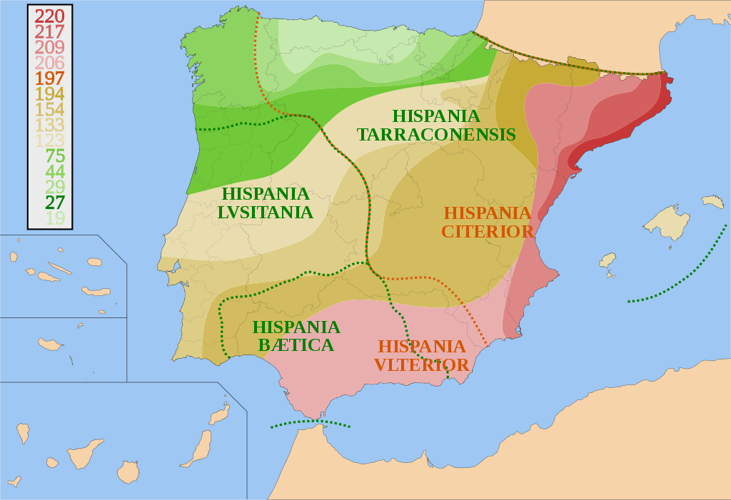
Español: Mapa de España y Portugal sobre la conquista de Hispania desde 220 a.C. a 19 a.C. y sus fronteras provinciales. Basado en otros mapas, los avances territoriales y fronteras provinciales son orientativos.
Català: Mapa d'Espanya i Portugal sobre la conquesta d'Hispania, des del 220 a.C. fins el 19 a.C. amb les fronteres provincials. És basat en altres mapes. Els avenços territorials i fronteres provincials són orientatius.
English: Map of Spain and Portugal showing the conquest of Hispania from 220 B.C. to 19 B.C. and provincial borders. It is based on other maps; the territorial advances and provincial borders are illustrative. |
| Fecha | |
| Fuente | Obra propio |
| Outor | HansenBCN |
Lisensia
I, HansenBCN, the copyright holder of this work, hereby publishes it under the following licenses:

|
Ta pèrmití kopia, distribuí i/òf modifiká e dokumento akí segun e GNU Free Documentation License, Vershon 1.2 òf kualke vershon mas resien publiká pa Free Software Foundation; sin Sekshon Invariante, sin teksto Front-Cover, i sin teksto Back-Cover. Un ehemplar di e lisensia ta inkluí den e sekshon yamá Lisensia di Dokumentashon Liber GNU. |
| E fail akí tin lisensia Creative Commons Attribution-Share Alike 3.0 Unported. | ||
| Atribushon: I, HansenBCN | ||
| ||
| This licensing tag was added to this file as part of the GFDL licensing update. |
Bo por skohe e lisensia preferí.
Historia di fail
Klek riba un fecha/ora pa mira e fail, manera e tabata na e momentu ei.
| Fecha/Ora | Miniatura | Dimenshonnan | Usuario | Komentario | |
|---|---|---|---|---|---|
| aktual | 19:46, 31 yüli 2007 | | 950 × 650 (1.07 MB) | HansenBCN | {{Information |Description= {{es|Mapa de España y Portugal sobre la conquista de Hispania desde 220 AEC a 19 AEC y sus fronteras provinciales.}} |Source=self-made |Date= July 31, 2007 |Author= HansenBCN }} [[Category:Maps of Roman Hisp |
Uso di fail
E próksimo page uses ta uza e fail akí:
Uso global di fail
E próksimo otro wikinan ta usa e fail akí
- Uso na an.wikipedia.org
- Uso na ar.wikipedia.org
- Uso na ast.wikipedia.org
- Uso na azb.wikipedia.org
- Uso na az.wikipedia.org
- Uso na bg.wikipedia.org
- Uso na br.wikipedia.org
- Uso na ca.wikipedia.org
- Uso na ckb.wikipedia.org
- Uso na cs.wikipedia.org
- Uso na da.wikipedia.org
- Uso na de.wikipedia.org
- Uso na el.wikipedia.org
- Uso na en.wikipedia.org
- Iberian Peninsula
- Lusitania
- History of Portugal
- 309
- Military history of Portugal
- Tarraco
- Portal:Portugal
- List of revolutions and rebellions
- Roman conquest of the Iberian Peninsula
- Hispania
- Ancient Carthage
- Warfare in the ancient Iberian Peninsula
- User:Amir.Vector
- Iberian revolt
- User:Silver Artemisa/sandbox
- User:Falcaorib/Ancient Empires (300 BC-01 AD)
- User:Botteville/mysandbox script repository
- Uso na es.wikipedia.org
Mira mas uzo global di e fail akí.