
File:Morina ruins.jpg

Tamaño di bista previo: 800 × 538 pixels. Otro resolushon: 320 × 215 pixels | 640 × 431 pixels | 1,024 × 689 pixels | 1,280 × 862 pixels | 2,560 × 1,723 pixels | 5,246 × 3,531 pixels.
Fail original (5,246 × 3,531 pixel, tamaño di fail: 12.93 MB, MIME type: image/jpeg)
Resúmen
| Deskripshon |
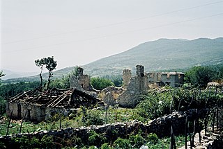
English: Ruins near Morina in the White Drin valley, at the border between Albania and Kosovo. A nearby village is called Planeja, the mountain to the right is called Pastrik. Taken in summer 2001 from a KFOR tank.
These buildings may have been destroyed in the attack, mentioned in the following quote: FOREIGN & COMMONWEALTH OFFICE, LONDON, JUNE 1999 23-24 May |
||
| Fecha | |||
| Fuente | Obra propio | ||
| Outor |
|
| Camera location | | View this and other nearby images on: OpenStreetMap |
|---|
I, the copyright holder of this work, hereby publish it under the following licenses:

|
Ta pèrmití kopia, distribuí i/òf modifiká e dokumento akí segun e GNU Free Documentation License, Vershon 1.2 òf kualke vershon mas resien publiká pa Free Software Foundation; sin Sekshon Invariante, sin teksto Front-Cover, i sin teksto Back-Cover. Un ehemplar di e lisensia ta inkluí den e sekshon yamá Lisensia di Dokumentashon Liber GNU. |
This file is licensed under the Creative Commons Attribution 3.0 Unported license.
- Bo ta liber:
- pa kompartí – pa kopia, distribuí i transmití e obra
- pa rekombiná – pa adaptá e obra
- Di akuerdo ku e próksimo kondishonnan:
- atribushon – Bo mester duna krédito na e outor, duna un lenk na e lisensia, i indiká si a hasi kambio. Bo por hasi esei na kualke manera rasonabel, perono na manera ku por sugerí ku esun ku ta otorgá e lisensia ta respaldá abo òf bo uzo.
Bo por skohe e lisensia preferí.
Historia di fail
Klek riba un fecha/ora pa mira e fail, manera e tabata na e momentu ei.
| Fecha/Ora | Miniatura | Dimenshonnan | Usuario | Komentario | |
|---|---|---|---|---|---|
| aktual | 14:11, 7 mart 2010 | | 5,246 × 3,531 (12.93 MB) | Watchduck | Reverted to version as of 16:04, 13 December 2009 |
| 20:48, 14 desèmber 2009 |  | 5,163 × 3,431 (12.44 MB) | Watchduck | color correction | |
| 16:04, 13 desèmber 2009 |  | 5,246 × 3,531 (12.93 MB) | Watchduck | There was a black border rest on the left side. | |
| 15:57, 13 desèmber 2009 |  | 5,258 × 3,531 (12.45 MB) | Watchduck | {{Information |Description={{en|1=Ruins near Morina in the White Drin valley, at the border between Albania and Kosovo. Taken in summer 2001 from a KFOR tank.}} |Source={{own}} |Author=[[U |
Uso di fail
No tin página ku ta uza e fail akí.
Uso global di fail
E próksimo otro wikinan ta usa e fail akí
- Uso na cs.wikipedia.org
- Uso na de.wikipedia.org
- Uso na en.wikipedia.org
- Uso na en.wikiversity.org
- Uso na fr.wikipedia.org
- Uso na id.wikipedia.org
- Uso na pl.wikipedia.org
- Uso na pt.wikipedia.org
- Uso na ru.wikipedia.org
- Uso na sh.wikipedia.org
- Uso na sq.wikipedia.org
- Uso na sr.wikipedia.org
- Uso na te.wiktionary.org
- Uso na www.wikidata.org
- Uso na zh.wikipedia.org