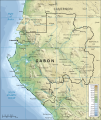
File:Topographic map of Gabon-fr.svg
Appearance

Size of this PNG preview of this SVG file: 506 × 599 pixels. Otro resolushon: 203 × 240 pixels | 405 × 480 pixels | 649 × 768 pixels | 865 × 1,024 pixels | 1,730 × 2,048 pixels | 815 × 965 pixels.
Fail original (Fail SVG, nominalmente 815x965 pixel, tamaño di fail: 1.69 MB)
Historia di fail
Klek riba un fecha/ora pa mira e fail, manera e tabata na e momentu ei.
| Fecha/Ora | Miniatura | Dimenshonnan | Usuario | Komentario | |
|---|---|---|---|---|---|
| aktual | 14:21, 3 aprel 2008 |  | 815 × 965 (1.69 MB) | Bourrichon | {{Information |Description=Traduction de Image:Topographic map of Gabon.svg |Source=travail personnel |Date=3 avril 2008 |Author= Bourrichon |Permission= |other_versions= <gallery> Image:Topographic map of Gabon.svg|''en'' </galle |
Uso di fail
E próksimo page uses ta uza e fail akí:
Uso global di fail
E próksimo otro wikinan ta usa e fail akí
- Uso na af.wikipedia.org
- Uso na arz.wikipedia.org
- Uso na ast.wikipedia.org
- Uso na avk.wikipedia.org
- Uso na azb.wikipedia.org
- Uso na ban.wikipedia.org
- Uso na be.wikipedia.org
- Uso na ca.wikipedia.org
- Uso na dag.wikipedia.org
- Uso na de.wikivoyage.org
- Uso na diq.wikipedia.org
- Uso na en.wikipedia.org
- Uso na en.wikiversity.org
- Uso na eo.wikinews.org
- Uso na fa.wikipedia.org
- Uso na ff.wikipedia.org
- Uso na fr.wikipedia.org
- Uso na fr.wikinews.org
- Uso na fr.wikivoyage.org
- Uso na fr.wiktionary.org
- Uso na ga.wikipedia.org
- Uso na gd.wikipedia.org
- Uso na gl.wikipedia.org
- Uso na gpe.wikipedia.org
- Uso na ha.wikipedia.org
- Uso na he.wikivoyage.org
- Uso na ia.wikipedia.org
- Uso na ig.wikipedia.org
- Uso na incubator.wikimedia.org
- Uso na it.wikipedia.org
- Uso na kab.wikipedia.org
- Uso na ku.wikipedia.org
- Uso na la.wikipedia.org
- Uso na mg.wikipedia.org
- Uso na pl.wikipedia.org
- Uso na rue.wikipedia.org
- Uso na rw.wikipedia.org
- Uso na shi.wikipedia.org
- Uso na sr.wikipedia.org
Mira mas uzo global di e fail akí.


