Jump to content

File:Dolina-Pano-3.jpg

Page contents not supported in other languages.
Di Wikipedia, e ensiklopedia liber

Fail original (1,500 × 2,607 pixel, tamaño di fail: 6.83 MB, MIME type: image/jpeg)

E fail akí ta di Wikimedia Commons i por us'é den otro proyekto. E deskripshon riba su página di deskripshon di fail ta indiká mas abou.

Resúmen

Deskripshon
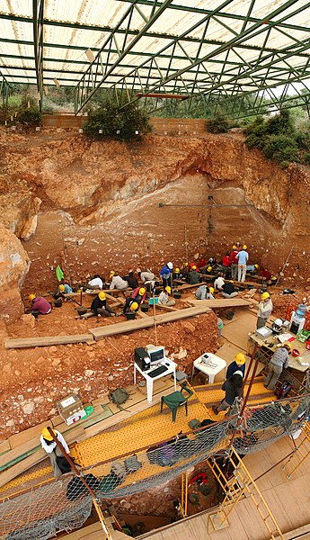
English: Excavations at the site of Gran Dolina, in Atapuerca (Spain), during 2008. Panoramic photography formed using 3 individual photographies with Hugin software. TD-10 archaeological level is being excavated where the most of the people are. It is a Homo heidelbergensis camp. Under the plank, we can observe a woman with red sweatshirt excavating TD-6 archaeological level, where were found the first remains of Homo antecessor.
Español: Excavaciones en el yacimiento de Gran Dolina, en Atapuerca (España), durante el año 2008. Fotografía panorámica formada a partir de 3 fotografías individuales usando Hugin. La excavación en la parte superior se corresponde con el nivel arqueológico TD-10, el cuál es un campamento de Homo heidelbergensis. La parte inferior, debajo de los tablones, se observa a una excavadora con sudadera roja que excava el nivel TD-6, donde aparecieron los restos del Homo antecessor.
Français : Fouilles menées en 2008 sur le site de Gran Dolina dans la Sierra d'Atapuerca, située dans la commune d'Atapuerca dans la province de Burgos en Castille-et-León (Espagne). Image panoramique obtenue en assemblant trois clichés avec le logiciel Hugin. Le niveau archéologique TD10, où se trouvent la plupart des personnes, est un camp d'Homo heidelbergensis. Sous les planches, on distingue une personne travaillant sur le niveau TD6, où ont été trouvés les premiers restes d'Homo antecessor.
Русский: Археологические раскопки в Атапуэрка, близ Гран-Долины (Испания), в 2008 году.
Fecha
Fuente Obra propio
Outor Mario Modesto Mata
Other versions
Camera location42° 21′ 06.33″ N, 3° 31′ 12.7″ W Kartographer map based on OpenStreetMap.View this and other nearby images on: OpenStreetMapinfo

Assessment

Featured image

Wikimedia CommonsWikipedia

This is a featured picture on Wikimedia Commons (Featured pictures) and is considered one of the finest images. See its nomination here.

 This is a featured picture on the English language Wikipedia (Featured pictures) and is considered one of the finest images. See its nomination here.

If you have an image of similar quality that can be published under a suitable copyright license, be sure to upload it, tag it, and nominate it.

Lisensia

I, the copyright holder of this work, hereby publish it under the following licenses:
w:en:Creative Commons
atribushon kompartí meskos
Bo ta liber:
  • pa kompartí – pa kopia, distribuí i transmití e obra
  • pa rekombiná – pa adaptá e obra
Di akuerdo ku e próksimo kondishonnan:
  • atribushon – Bo mester duna krédito na e outor, duna un lenk na e lisensia, i indiká si a hasi kambio. Bo por hasi esei na kualke manera rasonabel, perono na manera ku por sugerí ku esun ku ta otorgá e lisensia ta respaldá abo òf bo uzo.
  • kompartí meskos – Si bo meskla, transfrmáòf modifiká e obra bo mester distribuí bo kontribushonnan bou di [mes lisensia https://creativecommons.org/share-your-work/licensing-considerations/compatible-licenses òf unu kompatibel] ku esun original.
GNU head Ta pèrmití kopia, distribuí i/òf modifiká e dokumento akí segun e GNU Free Documentation License, Vershon 1.2 òf kualke vershon mas resien publiká pa Free Software Foundation; sin Sekshon Invariante, sin teksto Front-Cover, i sin teksto Back-Cover. Un ehemplar di e lisensia ta inkluí den e sekshon yamá Lisensia di Dokumentashon Liber GNU.
Bo por skohe e lisensia preferí.
Summary:

In using this image or any subsequent derivatives of it, you are required to release the image under the same license. As such, any reproduction of this image, in any medium, must appear with a copy of, or full URL of the license.

Attribution of this image to the author (Mario Modesto Mata) is required in a prominent location near to the image.

No other conditions may be added to, or removed from this license without the permission of the author and copyright holder.

Please review the full license requirements carefully before using this image. If you would like to clarify the terms of the license or negotiate less restrictive commercial licensing outside of the bounds of GFDL/CC-BY-SA, please contact me by email, or if you don't have a Wikipedia account you can leave a message on my talk page with your contact details and your request.


Click on the image to see my portfolio

Captions

Add a one-line explanation of what this file represents

Items portrayed in this file

ta portretá

42°21'6.329"N, 3°31'12.698"W

data size ingles

7,165,321 byte

2,607 pixel

width ingles

1,500 pixel

media type ingles

image/jpeg

checksum ingles

ae1d4331df0857894d217c84a7d371d27f0341f3

Historia di fail

Klek riba un fecha/ora pa mira e fail, manera e tabata na e momentu ei.

Fecha/OraMiniaturaDimenshonnanUsuarioKomentario
aktual13:48, 7 sèptèmber 2008Miniatura di e vershon di 13:48, 7 sèptèmber 20081,500 × 2,607 (6.83 MB)Mario modesto{{Information |Description={{en|1=Excavations at the site of Gran Dolina, in Atapuerca (Spain), during 2008. Panoramic photography formed using 3 individual photographies with Hugin software. TD-10 archaeological level is being excavated where the most of

E próksimo page uses ta uza e fail akí:

Uso global di fail

E próksimo otro wikinan ta usa e fail akí

Mira mas uzo global di e fail akí.

Metadato